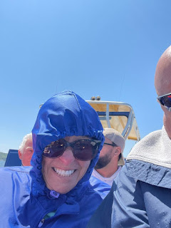
Our temperatures dipped to 37 degrees F early this morning but with our ceramic heater and fireplace, and the extra blanket on the bed we were warm. We had a relaxing morning here at the campground catching up on the computer a bit and doing some tasks while we waited for the time to depart for our Thursday adventure - a "RipTide" jetboat ride around Grand Island.
Our "show time" was 1230 hrs but we always try to be a bit early as it can be challenging finding a parking spot for the big ol' brown truck. Good thing as the line had already started to form and seating was first come first served.
Promptly at 1300 hrs we took off from the dock and once outside the no-wake area he gave it the gas and the first of many spins occurred! After everyone got a good spray of water, we headed towards Grand Island. On the way the Captain reminded us that he was in complete control and he could soak us basically any time he wanted to! Compliance!!! It was "all part of the experience" as Clark W. Griswold would say!
Grand Island is a half mile from Munising and the mainland. From RipTide's web site, the name Munising is derived from the Ojibwa word “Minnising”, meaning “Place of the Great Island”, referring to Grand Island. The shoreline follows 35 miles all the way around and the island is 5 ½ times larger than Mackinac Island, including 13,600 acres of dense woodland and two lakes. You can take a shuttle boat to Grand Island in the summer and hike or bike the trails. In the winter it can be accessed across the ice.
So the journey around Grand Island started at the south end and to Doreen's delight, the first attraction came into view - East Channel Lighthouse! If any of you followed us in September 2020 you saw the pictures we captured of this lighthouse with the colorful fall foliage in the background, and that was from a distance as we rode the Pictured Rocks Sunset Cruise. Today we got up close and personal, stopping the boat within a few meters of the shore. Even though Grand Island is all federally owned now, the lighthouse is privately owned as is the one on the northern shore. This lighthouse is showing it's age. We can only hope the owner will maintain it so it does not further deteriorate.
Our boat ride continued around the east side of the island and, as illustrated on the map above, there are attractions all along the way. In between attractions the Captain gave us a few spins just to keep us wet enough so the wind chill would set in as we cruised!! Our temperatures hovered around 55F. Here are some pictures:
As we continued around the island the Captain pointed out some eagles nests and a couple bald eagles.
We rounded the north side and the North Light Lighthouse came into view, but only after we went out a ways and looked back. This lighthouse sits at 800 ft above sea level, so it is the highest lighthouse above sea level in the world!
We continued around the west side of the island passing more waterfalls and beautiful rock formations.
We thought it was ironic that our Captain would give us an up close and personal with one specific waterfall, called "Cedar Falls"! Cedar Falls Iowa is Doreen's home town and where we both graduated high school 50 years ago.
We continued on south and 90 minutes after our departure we arrived back at the dock. Everyone appeared to have a great time and enjoyed the trip.
They sell their original beef pastie, chicken pastie, vegetable pastie and also dessert pasties. Doreen got the veggie with chicken gravy and I got the traditional with beef gravy. Then we got an apple pastie to share for dessert. We took this back to the campground and enjoyed them outside in the sun on the picnic table.


No comments:
Post a Comment